Approved by COSEWIC in November 2021
Printable version (PDF - 301 kB)
Table of contents
COSEWIC status reports and the review process: an overview
COSEWIC (Committee on the Status of Endangered Wildlife in Canada) bases its status assessments on status reports, which compile and analyze the best available information regarding the status of Wildlife Species1 in Canada and the threats facing them. A status report can be a full report or one of several types of summary reports, appended to a full status report. These instructions deal with full status reports. The status report must meet standards of quality, completeness, and format as outlined in this document. Status reports are written by knowledgeable individuals (hereafter referred to as “report writers”) who are fulfilling contracts by COSEWIC “Call for Bids” process or a sole source process, or are submitting unsolicited status reports.
The primary purpose of a status report is to provide sufficient information for accurate status assessment of a Wildlife Species. The report also plays a role in subsequent SARA processes, such as listing, recovery, and permitting. The report writer is expected to access the best available published and unpublished information on the species. The Secretariat provides separate instructions for accessing Aboriginal Traditional Knowledge (ATK) and integrating it in status reports. The writer is responsible for accurately evaluating and synthesizing information, with an emphasis on key aspects that can be used to determine status. The most important types of information include estimates of population size and trends, distribution, habitat quality and trends, and threats. It is also useful to identify gaps in knowledge and uncertainty associated with data or inferences.
There are several stages in the preparation of a COSEWIC status report (Table 1). The average time from when the contract is awarded to the assessment is approximately two and a half to three years. Posting of the finalized report on the SARA Public Registry may occur from six months to over a year later.
- “Draft Report". This version is based on the first rough draft of the report received from the report writer by the Secretariat and the responsible Specialist Subcommittee (SSC) Co-chair, and revised with input from the Co-chair. If fieldwork is included in the contract, the results of the separate Field Verification report are included in a summary form in the Draft Report. The report is reviewed by the SSC, jurisdictions with responsibility for that Wildlife Species (“range jurisdictions”), and external experts at the discretion of the SSC Co-chair. Comments and suggestions are sent to the SSC Co-chair and forwarded to the report writer with instructions from the Co-chair for changes that must be incorporated into the report.
- “Provisional Report”. This is the writer’s revision of the Draft Report incorporating results of the draft review. Once changes have been made, the involvement of the report writer may be concluded if specified in the contract. Usually, however, the report writer’s contract includes a further stage of revisions (see next paragraph).
- “Six-month Interim Report”. The SSC uses the provisional report to produce an interim report, which is sent to the jurisdictions at least six months before a COSEWIC Wildlife Species Assessment Meeting (WSAM). Usually, at the direction of the Co-chairs, the report writer incorporates revisions resulting from the six-month review. Such post-provisional revisions are usually part of the original contract with the report writer. The SSC subsequently may add additional information or analysis, or make changes as deemed necessary.
- “Two-month Interim Report”. The SSC adds a recommendation of status to the revised report, which is then sent to all members of COSEWIC at least two months before the WSAM where it will be discussed and the proposed status and supporting assessment criteria will be voted on. The SSC and COSEWIC assume responsibility for further revision and completion of the report.
- “Final Report”. Following assessment, the SSC Co-chair finalizes the status report, incorporating any changes requested by COSEWIC during the WSAM. The report is then translated and published on the SAR Public Registry as a “COSEWIC assessment and status report”.
| Focus on the report writer and contract | Focus on COSEWIC | |
|---|---|---|
| 1 | Writers submit DRAFT STATUS REPORT* on contracted due date and incorporate initial edits from SSC Co-chair. | |
| 2 | DRAFT STATUS REPORT sent for three-month jurisdictional and SSC review. | |
| 3 | Writers submit PROVISIONAL STATUS REPORT on contracted due date. | |
| 4 | SIX-MONTH INTERIM STATUS sent for three-month jurisdictional review (at least SIX MONTHS before assessment meeting) | |
| 5 | Writers submit POST-PROVISIONAL STATUS REPORT (if milestone included in contract) | |
| 6 | TWO-MONTH PROVISIONAL STATUS REPORT sent to COSEWIC (at least TWO MONTHS before assessment meeting) | |
| 7 | Co-chair submits FINAL STATUS REPORT | |
| 8 | FINAL STATUS REPORT posted on SARA Public Registry after COSEWIC annual report delivered to Minister of ECCC. |
Unsolicited Reports
Unsolicited reports are reports that have not been commissioned by COSEWIC. COSEWIC will consider applications from any source, including but not limited to provincial, territorial, or federal agencies. Unsolicited status reports must be accompanied by a completed Application for Wildlife Species Assessment. The full completed application and unsolicited status report are submitted to the Secretariat, which forwards it to the appropriate SSC Co-chair. The report writer may be asked to make editorial changes, add available information, and/or delete inapplicable sections of the report as specified by the responsible Co-chair. Failure to comply with such requests may result in a report being returned “not received” by COSEWIC.
Writers of unsolicited status reports are informed whether the report was accepted or rejected by COSEWIC, and if accepted, the report goes through the same assessment process as described for commissioned reports. If the report is rejected, COSEWIC provides the report writer with the reason(s).
In cases where a report concerns a Wildlife Species in a taxon for which there is currently no SSC (e.g., annelids, echinoderms, cnidarians), an ad hoc SSC may be struck by the Chair of COSEWIC for the purposes of the assessment process.
Intellectual property (IP) and moral rights
For all COSEWIC reports, IP2 will be retained by the Government of Canada (“the Crown”), so that the reports can be published on the public registry.
COSEWIC will be cited as “author” for all reports initiated after May 2001. The report writer(s) will be acknowledged in the final status reports posted on the SARA public registry, and the roles of other contributors will be recognized. The report writer may, however, opt out of acknowledgement of their role in the status report if they wish. In the case of updated status reports, all report writers involved in the preparation of the original status report and any previous updated reports on the Wildlife Species will also be acknowledged.
Property Rights in ATK
ATK is the property of those who hold it. In the rare event that contractors are requested to gather ATK, they will be required to use appropriate consent forms provided by the ATK subcommittee. Knowledge holders will be provided with an opportunity to review and validate the factual information shared with the report writer before it is integrated into the status report. Raw information (e.g., transcripts, tapes, etc.) will be returned to the knowledge holder or the community for storage. The report writer(s) shall not have any intellectual property rights in relation to the knowledge provided from Indigenous sources.
General content of reports and formatting
The role of the report writer is to synthesize the best available information from multiple sources and to present it objectively. All sides of contentious issues should be presented, so that interpretations by SSCs and COSEWIC are well informed. The report writer is expected to review the most up-to-date COSEWIC guidelines and definitions (see Information for Preparing COSEWIC Status Reports on the COSEWIC website) when presenting information on key issues, such as Designatable Unit structure and threat-based locations.
Required Contacts and Other Sources of Information
In addition to conducting a thorough review of the relevant scientific literature, the report writer must contact the jurisdictions (federal, provincial, and territorial) where the Wildlife Species is/was found to ensure that the report contains the best and most current information from all possible sources. Often substantial information is in technical reports or other sources of “grey literature”. If the Wildlife Species occurs within the jurisdiction of Wildlife Management Boards (WMBs), the appropriate WMBs must also be contacted. The report writer must contact the COSEWIC Secretariat for more information and instructions on integrating ATK into reports, preparing distribution maps, and calculating the extent of occurrence and index of area of occupancy. The report writer must also contact relevant Canadian Conservation Data Centres or Natural Heritage Information Centres, and the chair of the recovery team for the Wildlife Species, if one exists. Contact information for all agencies mentioned above is provided in Required Contacts for Information on Wildlife Species on the COSEWIC website. The report writer should also include information from other credible sources, such as personal communications with species experts, report writers of possible previous versions of the status report, and other experts, as deemed relevant. Every effort should be made to substantiate personal communications or provide corroborating information from multiple sources.
Including ATK in Wildlife Species Assessments
It is the responsibility of the report writer to include ATK on those Wildlife Species for which ATK is available. This will be facilitated by contacting the COSEWIC Secretariat ATK coordinator (see Required Contacts for Information on Wildlife Species on the COSEWIC website) to advise that a new or updated Wildlife Species status report is in preparation. If the report writer is aware of additional sources of ATK that are not publicly available, the ATK Subcommittee Co-chairs must be advised before making contact with a potential ATK source. ATK will be included when it becomes available, at any stage of report preparation.
Available ATK should be incorporated throughout the status report in relevant sections under the guidance of the ATK Subcommittee and assisted by the COSEWIC Secretariat. Relevant fields may include, but are not limited to, distribution, population size and trends, and threats and potential mitigating factors, including management plans and harvesting restrictions.
Including specific information on Aboriginal cultural, medicinal, or spiritual use of a Wildlife Species is inappropriate and unnecessary. It is appropriate, however, to identify that a Wildlife Species is used by or has special value for an Aboriginal group.
The report writer is to provide a list to the ATK Subcommittee of the names of all the people who were contacted for the purpose of accessing ATK.
The inclusive term “Indigenous Peoples”, or more specific terms such as Inuit, First Nations, or Métis, are to be used when referring to people and “Aboriginal” when referring to information when integrating ATK into the status report.
Sensitive Information
Once approved by COSEWIC, the final status report will become a public document. The report writer should ensure that any detailed information that might further imperil a Wildlife Species and that is not necessary for the assessment does not appear in the draft status report. Examples include the precise locality or habitat of subpopulations vulnerable to poaching or persecution, as well as confidential information, such as ownership of private lands or specific details relating to ATK. This level of detail is usually not necessary for status assessment and could encourage interference with subpopulations that are already at risk; it may also have repercussions for access to private lands or to ATK in the future, or hinder other conservation work. If such sensitive information is deemed important for the assessment, it should be clearly marked for possible later deletion. Sensitive information used for the report (e.g., for preparation of maps; field reports) must be submitted separately to the SSC Co-chair and the COSEWIC Secretariat. Refer to COSEWIC Guidelines Concerning Data Sharing and Information Security (O&P Appendix F8) for more information on COSEWIC’s processes for identifying Wildlife Species with Sensitive Occurrence Data, to facilitate completion of the corresponding box in the Technical Summary.
Updated Status Reports
For species previously assessed by COSEWIC, a review of classification under SARA is expected to be conducted every 10 years. A Wildlife Species may be reclassified sooner, if new information so warrants. As COSEWIC is the author for reports initiated after May 2001, relevant information can be extracted and used verbatim in the update status report; these are “living documents” containing a complete summary of the knowledge to date. The report writer should thus contact the COSEWIC Secretariat to obtain a Word version of the previous report. The format, organization, and information required for COSEWIC status reports may have changed substantially since the publication of the previous report. However, the previous report usually contains much information that is still relevant, such as on the biology of the species that can be used in the update. It is the report writer’s task to evaluate what information is still relevant, considering that the current priority is to focus on factors directly affecting status and assessment criteria. The report writer is expected to check that the information carried over to the update report is still relevant and accurately referenced. Excessive detail and “nice to know” information must be omitted. Updated status reports should provide the same comprehensive summary of information about the Wildlife Species and its current status in Canada as a new report and use the current guidelines, definitions, and format. Thus, the instructions and requirements in this manual apply equally to new and updated status reports.
In some situations where it is suspected that the Wildlife Species’ status has not changed, COSEWIC may decide to prepare a short Status Appraisal Summary (SAS), which outlines relevant new information pertaining to the status. Other short formats used by COSEWIC for review of classification include Rapid Review of Classification (RRoC) and Addendum (used in exceptional cases for change of status). Such documents supplement the existing full status report.
General Content and Formatting
Status reports may be written in English or French. Reports written in French are translated into English at each stage, in which case the report writer’s contract will extend over a longer period to allow time for translation. Use the Formatting Template for Status Reports provided in Status Report Formatting Template of the COSEWIC website (O&P Appendix F3). Inclusion of all headings and subheadings specified in the template is required (unless otherwise noted). This will ensure coverage of all topics relevant to decision-making by COSEWIC. If information for some subheadings is deficient, this should be indicated. New subheadings may be added as necessary, depending on the taxon.
COSEWIC is striving to streamline status reports as much as possible, to focus on the information most important to status determination. Report length will vary depending on the amount of information available. Reports should summarize all relevant information but omit extraneous details. The report writer’s task is not to be exhaustive but rather to select the relevant material needed for assessment and succinctly summarize, reference, and synthesize it for COSEWIC’s use. The report writer should strive to be brief, but bullets and lists should be generally avoided.
It is important to use COSEWIC’s definitions for populations and subpopulations, especially when writing about a species’ distribution and population structure and trends, and to avoid the use of the term “location” except in the context of specific meaning related to threats. Key terms are described below, but the report writer should consult the Glossary on the COSEWIC website (Definitions and Abbreviations) for detailed definitions of these and other terms.
- Population is the total number of mature individuals of the Wildlife Species (i.e., Designatable Unit) in Canada.
- Subpopulation is a geographically or otherwise distinct subset of the population that has little demographic or genetic exchange with other such groups - typically one successful migrant individual or gamete per generation or fewer. For some Wildlife Species there is only a single population and no subpopulations.
- Location is a geographically distinct area in which a single threatening event can rapidly affect all individuals of the Wildlife Species present. The size of the location depends on the area covered by the threatening event and may include part of one or many subpopulations or the entire population. Where more than one threatening event is possible, location should be defined by considering the most serious plausible threat. Figure 1 illustrates the differences between subpopulations and locations.
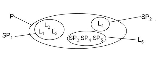
For explanations of terms, see text. Note that populations and locations can form subsets of each other depending on the nature of the threats to the wildlife species.
The report should be written in the third person, as the “author” of the report will eventually be COSEWIC. Information Sources provides guidance for citing literature or personal communications.
All tables and figures are to be numbered and referred to in the text of the report sequentially in the order presented and referenced in the text i.e., Figure 1 before Figure 2. Figures may use some colour but must photocopy well in black and white, and all legends and symbols must be clear when rendered in black and white.
English names (or French if the report is written in French) are to be used throughout the report. If they are not available and easily understood, place names in local language should be provided in the original form (not translated into English). In addition to English names, place names in a local language should be provided upon first use if doing so aids in understanding, e.g., if in common use in the local area or scientific literature. Indigenous place names should be provided when available with advice from the ATK Subcommittee.
Map scales are to be in metric units. Metric conversions can be provided in brackets when quoting a source that uses non-metric units. The measure of variability used is to be specified (e.g., standard error, standard deviation, quartiles) when quantitatively reporting uncertainty.
Instructions on writing numbers and abbreviations follow The Canadian Style.
Detailed instructions
The following instructions supplement the guidelines provided in the Formatting Template for Status Reports (O&P Appendix F3) on the Template for COSEWIC Status Reports page of the COSEWIC website; both should be consulted simultaneously when writing a status report. Any specific questions may be directed to the SSC Co-chair responsible for shepherding the report through the COSEWIC status assessment process.
Title page
Use the formatting provided in the Formatting Template for Status Reports (O&P Appendix F3).
Executive summary
The Executive Summary is intended as a brief stand-alone summary for a general audience. The SARA program also uses this text in public consultation documents and other information materials. Concisely summarize key elements of the report, focusing on aspects relevant to status assessment; only include information presented in the body of the report. Avoid jargon, technical language, and facts that may mean little to the public. Use the common names of Wildlife Species, but provide the scientific name upon first use. Do not reference figures or tables or include literature citations.
Technical summary
A blank version of the Technical Summary is available as part of the Formatting Template on the COSEWIC website. After the body of the report is written, complete a separate Technical Summary for each proposed Designatable Unit (DU), following guidance provided in the Formatting Template. If the proposed DU structure has not been formally approved by COSEWIC, discuss with the Co-chair whether to provide a separate Technical Summary for the entire species within Canada; this will be placed before the others. All content in the Technical Summary must be supported by more detailed text in the body of the report.
The SSC will complete the tables for “Recommended Status and Reasons for Designation” and “Applicability of Criteria” at the end of the Technical Summary for the Two-month Interim Status Report. COSEWIC will approve or modify the text in this section for the Final Report.
Preface (only used for updated status reports)
See guidance in the Formatting Template for Status Reports (O&P Appendix F3) on the Template for COSEWIC Status Reports page of the COSEWIC website.
Wildlife species description and significance
Name and Classification
Provide the most up-to-date accepted scientific name, in agreement with the taxonomic standards used by the relevant SSC. Include authority at the first mention of the name of the species. Follow scientific writing format for nomenclature. The species name, a binomial, always includes the genus. If needed, consult the responsible SSC Co-chair regarding specific information or references for taxonomy.
Provide information on classification. List the recognized subspecies (or varieties) that occur in Canada. Discuss any recent taxonomic or nomenclatural changes or taxonomic problems or uncertainties, if applicable. Provide common names in English, French, and Indigenous languages if available; for approved Indigenous names, consult the ATK Subcommittee through the COSEWIC Secretariat. Include the reference source of the French common name. Give synonyms for names if there is likely to be confusion. If the correct usage of a name is controversial, very briefly review the history related to the application of the names.
For the framework for naming COSEWIC Wildlife Species and the taxonomic standards used by SSCs, refer to COSEWIC Guidelines for Naming Wildlife Species (O&P Appendix E4) included on the Information for Preparing Status Reports page of the COSEWIC website.
Description of Wildlife Species
Provide an accurate but brief morphological description of the species using non-technical language. Whenever possible, provide references to easily accessible descriptions, illustrations, or keys instead of a detailed description. If appropriate, include diagnostic features differentiating the species from similar or easily confused co-occurring species. For species with various life stages (e.g., larvae) or sexual dimorphism, briefly describe them. Avoid describing life stages such as insect eggs unless they are particularly diagnostic.
For lichens, information on characteristic chemical components should be mentioned. For organisms where auditory signals are diagnostic and help in identification (e.g., anurans), these features may be briefly described.
Provide a drawing or clear photograph with good contrast (i.e., must photocopy well in black and white) of the species to be used on the cover page of the final published document; provide the credit for the photographer or artist. For photographs, including generalized locality and time is desirable. It is unnecessary to repeat the illustration as a figure. The illustration is to be submitted as a separate high-resolution electronic file but should also be embedded at lower resolution in the report. If the illustration is from a published document or belongs to someone other than the report writer, a letter of permission from the author/owner of the illustration must be submitted to the COSEWIC Secretariat.
Designatable Units
COSEWIC generally assesses the status of a taxonomic species in Canada, in which the entire species is considered one Designatable Unit (DU). In some cases, however, assessment below the species level is warranted. DUs correspond to “Wildlife Species” under SARA, and the two terms are used interchangeably in this document. COSEWIC recognizes units below the level of a recognized taxonomic species as DUs if they have attributes that make them both "discrete" and "evolutionarily significant". The Guidelines for Recognizing Designatable Units (O&P Appendix F5) included on the Information for Preparing Status Reports page of the COSEWIC website identify the criteria for evaluating putative DUs. Writers must consult and understand these guidelines. Contact the SSC Co-chair for advice if needed. If there is only a single DU, briefly justify the lack of distinctiveness within the taxonomic species. If more than one DU is proposed, use the criteria for discreteness (D1, D2) and significance (S1, S2) (O&P Appendix F5 and copied below), and discuss the applicability of each. If the DU structure is particularly complex, a separate DU report may have been commissioned. In such cases, use the DU report as your source, with citation, to complete the DU section of the report.
Discreteness:
A putative DU may be considered discrete based on one or both of the following criteria, each of which indicate little or no transmission of heritable information between it and other DUs:
D1. Evidence of heritable traits or markers that clearly distinguish the putative DU from other DUs (e.g., evidence from genetic markers or heritable morphology, behaviour, life history, phenology, migration routes, vocal dialects, etc.), indicating limited transmission of this heritable information with other DUs.
D2. Natural (i.e., not the product of human disturbance) geographic disjunction between putative DUs such that transmission of information (e.g., individuals, seeds, gametes) between these "range portions" has been severely limited for an extended time and is not likely in the foreseeable future. “Extended time” is intended to mean that sufficient time has passed that either natural selection or genetic drift are likely to have produced discrete units, given the specific biology of the taxon.
Significance:
If a putative DU is found to be discrete, its significance can be assessed. A DU is considered significant based on one or more of the following criteria. These criteria capture two types of significance that can operate together or separately: (i) an evolutionarily significant period of isolation that is expected to generate an evolutionary history that cannot be reasonably expected to be practically reconstituted (criterion 1); and/or (ii) the presence of specific adaptive, heritable traits (phenotype) that may develop in a shorter time-frame but that nevertheless cannot be reasonably expected to be reconstituted (criterion 2).
S1. Direct evidence or strong inference that the putative DU has been on an independent evolutionary trajectory for an evolutionarily significant period, usually intraspecific phylogenetic divergence indicating origins in separate Pleistocene refugia.
S2. Direct evidence or strong inference that can be used to infer that the putative DU possesses adaptive, heritable traits, that cannot be practically reconstituted if lost. For example, persistence of the discrete, putative DU in an ecological setting where a selective regime is likely to have given rise to DU-wide local adaptations that could not be reconstituted. See Practical Considerations/Best Practices in O&P Appendix F5.
Refer to Table 1 in the COSEWIC DU guidelines for an example on how to summarize pairwise differences between putative DUs.
For status reports commissioned by COSEWIC, the treatment of DUs will normally be specified in the Call for Bids and the Terms of Reference of the contract. Consult the SSC Co-chair if new information relevant to the previously approved DU structure has come to light that may warrant modifications to the DU boundaries or structure.
In each subsequent section of the report, ensure that the key information for assessment (e.g., distribution, population size, trends, threats) is provided for each DU, using appropriate subsection headings. If biological information differs between DUs, identify the differences. Be consistent in the order of information presented if there is more than one DU.
Special Significance
See guidance in the Formatting Template for Status Reports (O&P Appendix F3) on the Template for COSEWIC Status Reports page of the COSEWIC website.
Aboriginal (indigenous) knowledge
Include standard text as per the Formatting Template for Status Reports (O&P Appendix F3) on the Template for COSEWIC Status Reports page of the COSEWIC website.
Cultural Significance to Indigenous Peoples
The COSEWIC Secretariat will provide the report writer existing Aboriginal Traditional Knowledge Subcommittee (ATK SC) Source and/or Assessment reports and an ATK Integration Manual (when it becomes available). Note that ATK SC reports are not available for all species. The report writer should also search for publicly available information on ATK from other sources. ATK is to be integrated under appropriate status report section headings, thus giving equal consideration to both knowledge systems.
Include standard text as per the Formatting Template for Status Reports (O&P Appendix F3) on the Template for COSEWIC Status Reports page of the COSEWIC website. The ATK Subcommittee may provide modifications or additions as required.
Distribution
This section deals with the description of geographic range, extant and past localities, and changes in these parameters over time. Briefly summarize how distribution was determined, with details appropriate to the taxon provided by referring to Appendix A, also part of this document. Information on population size and trends is to be placed in Population Size and Trends. Where relevant, include a discussion on uncertainties associated with distributional data, such as for poorly known species.
See Sensitive Information under the General Contents of Reports and Formatting in this document) for addressing distributional information that may be deemed sensitive (e.g., precise localities, land ownership. Consult with the SSC Co-chair if potentially sensitive occurrence data are suspected or encountered.
Global Range
See guidance in the Formatting Template for Status Reports (O&P Appendix F3) on the Template for COSEWIC Status Reports page of the COSEWIC website.
Canadian Range
Indicate whether the species is endemic to (occurs only in) Canada or the proportion of the global distribution that is in Canada. Provide a summary of the species' current Canadian distribution. Indicate whether the range is wide or restricted. Describe evidence for fragmentation or disjunctions. Indicate the biogeographic zones in which the species occurs (O&P Appendix F5; see Guidelines for Recognizing Designatable Units included on the Information for Preparing Status Reports page of the COSEWIC website). If applicable, identify areas of importance (e.g., high abundance) in broad terms. If the species is dependent on another species for survival, provide information on the Canadian distribution of the other species as well.
If the Wildlife Species has been subjected to human intervention, there must be a discussion based on the COSEWIC Guidelines on Manipulated Wildlife Species (O&P Appendix E7) included on the Information for Preparing Status Reports page of the COSEWIC website, addressing which components are included and excluded from the assessment. If relevant and feasible, clearly identify plants of horticultural origin and make a distinction between material derived from known native Canadian sources and horticultural stock of unknown origin.
Include a brief paragraph on the adequacy of search effort to document the Wildlife Species’ distribution and whether significant data gaps exist in the survey coverage. Where possible, include the proportion of potential habitat searched. If additional information on search effort is deemed relevant to the assessment, as with poorly known cryptic species, provide details of survey effort in an appendix (see Appendix F1-A for further information).
Provide an up-to-date map showing the current and past distributions of the species in Canada. A range map (e.g., eBAR map) is desirable if available. If dealing with more than one DU, use an informative base map, such as biogeographic zones or watersheds, and clearly label the distribution of each DU. When applicable, distinguish between breeding, wintering, migratory, or other seasonal areas and routes. Ensure that maps are not so detailed that exact locality information is discernible. Make the scale of the distribution map appropriate to the geographic extent of the Wildlife Species’ distribution (e.g., do not show the entire country when the distribution is limited to a region of Canada). However, an insert map may be useful for clarifying context.
Population Structure
Provide information about population structuring within the Wildlife Species and discuss whether there is evidence for distinct subpopulations as defined by COSEWIC. Explain how subpopulations, occurrences (or element occurrences as defined by NatureServe), sites, and other spatial terms are used in the report and how they relate to each other. Do not repeat genetic and other evidence that was presented in the DU section, but refer to it for broad-scale patterns as needed. Discuss whether there are geographical, ecological, or behavioural barriers to movement that have created or might create genetic structure or strong demographic isolation, and if these barriers are human created or natural. Where available, briefly describe genetic measures of subpopulation variability, providing sufficient information on the types of analyses and results to permit assessment of the robustness of the data.
Extent of Occurrence and Area of Occupancy
Before writing this section, contact the COSEWIC Secretariat (see Required Contacts for Information on Wildlife Species on the COSEWIC website) to obtain detailed instructions and to ensure that methods and concepts are applied correctly. The Secretariat will assist with the preparation of distribution maps and the calculations of the extent of occurrence (EOO) and index of area of occupancy (IAO).
Whether the maps are prepared by the report writer or with help from the COSEWIC Secretariat, submit all survey data (species observations and localities) used in the mapping to the responsible SSC Co-chair and the COSEWIC Secretariat. These data may be collected during field verification performed in the course of writing of the status report or obtained from third parties (e.g., federal, provincial, and territorial jurisdictions, Conservation Data Centres, recovery teams, museums, private individuals). Reasonable effort should be made to ensure that the data obtained from third parties can be transferred to COSEWIC by obtaining data sharing licenses or agreements (O&P Appendix F8; COSEWIC guidelines concerning sensitive information). Final map versions prepared by the report writer must be submitted to the COSEWIC Secretariat in a format compatible with a Geographic Information System (GIS).
EOO is the area contained within the shortest continuous boundary encompassing all known, inferred, or projected sites of current occurrence of the Wildlife Species in Canada, excluding cases of vagrancy. EOO is measured by drawing the smallest minimum convex polygon (i.e., no internal angle exceeds 180 degrees) that contains all occurrences (Figure 2). The EOO often includes large areas of obviously unsuitable habitat such as stretches of ocean or lakes for terrestrial species, or land for marine or aquatic species; however, the complete EOO, including the unsuitable habitat, is required for assessment (i.e., EOO thresholds for criterion B1; O&P Appendix E3; see also the Quantitative Criteria and Guidelines used by COSEWIC for Wildlife Species Assessments on the COSEWIC website).
The entire EOO including unsuitable habitat is required for applying criterion B1, and it is always presented in the report. EOO also can be used for examining broad trends in range over time (i.e., for applying criteria Ac and B1bi); in these cases, tracts of unsuitable habitat (e.g., stretches of ocean for terrestrial species or land for aquatic species) may be removed from the EOO calculation. Consult with the SSC Co-chair to determine if EOO with unsuitable habitat removed should be calculated.

Figure 2. Estimating extent of occurrence. The method is correct in (a) and incorrect in (b). In (a) the outer most sites of occurrence (stars) are connected with a line such that no internal angle exceeds 180o; the enclosed area is the extent of occurrence. In (b) the line drawn has several internal angles (arrows) that exceed 180o and the extent of occurrence would be underestimated.
The area of occupancy is defined as the area within the EOO that is occupied by the Wildlife Species, excluding cases of vagrancy. The measure reflects the fact that a species will not usually occur throughout the entire area of its EOO, which may contain unsuitable or unoccupied habitats. In some cases (e.g., irreplaceable colonial nesting sites, crucial feeding sites for migratory taxa, communal hibernation sites), the area of occupancy is the smallest area essential at any stage to the survival of the Wildlife Species; for migratory species, this area does not need to occur in Canada. The area of occupancy can be measured in two ways: as a biological area of occupancy and as an index of the area of occupancy (IAO). IAO is used in the quantitative assessment criteria. However, the biological area of occupancy can be important to the overall assessment, for example, when evaluating habitat trends or fragmentation.
The biological area of occupancy is essentially the total area of habitat occupied by the Wildlife Species. Include this measure if there is biologically-defensible information about the area of occupied habitat, that is, enough accurate information on where the Wildlife Species occurs and does not occur. For a plant species, the actual area of each occupied site might be known and therefore can be simply added up. For bird species the actual area of occupied habitat is often unknown, but the number of pairs and the average home range size can be estimated; the area of occupancy can therefore be roughly estimated by multiplying these two values. Because Wildlife Species vary greatly in the amount of habitat required to sustain a population, e.g., from a few square centimetres for a lichen to thousands of hectares for a Caribou population, the size of the area of occupancy is a function of the scale at which it is measured.
IAO is an index that aims to provide an estimate of the area of occupancy that is independent of scale and can be compared across taxonomic groups and against COSEWIC’s quantitative assessment criteria. IAO is measured as the surface area of grid cells that intersect the actual area occupied by the Wildlife Species (i.e., the biological area of occupancy). COSEWIC requires that this index be calculated based on a grid with a cell size of 2x2 km; in specific circumstances, COSEWIC allows the use of a cell size of 1x1 km. A 1x1 km grid may be used if (a) enough data are available and (b) the smaller grid is justified based on, for example, a very specific habitat requirements such as freshwater or sand dunes (O&P Appendix F6; see also the Guidelines for use of the Index of Area of Occupancy in COSEWIC Assessments included on the Information for Preparing COSEWIC Status Reports page of the COSEWIC website). In these cases, IAO based on a 2 x 2 km grid must also be calculated and reported. Consult with the responsible SSC Co-chair to determine if an alternative to the 2 x 2 km grid cell calculation is warranted.
Provide estimates (in km2) of current EOO and IAO for each DU, based on sites considered extant. Sites classified as historical, often defined by lack of records within the past 20 years, should be included in the calculations if habitat still exists and recent search effort is deemed inadequate; in these cases, provide an explanation. If EOO is less than IAO, EOO should be changed to make it equal to IAO to ensure consistency with the definition of IAO as an area within EOO.
Fluctuations and Trends in Distribution
Describe any trends or fluctuations in EOO and IAO. Changes in distribution over the past three generations or 10 years, whichever is longer, are of particular interest as they relate to the application of assessment criteria. Provide quantitative evidence when possible. For reassessments, when comparing current and past values for EOO and IAO, recalculate the previously given values using the most up-to-date dataset and methodology to ensure consistency and enable comparison with current values. Differentiate among extirpated, historical, and extant occurrences, as appropriate, and define these categories at first use. Account for differences when comparing current values to previous or historical values, emphasizing whether they reflect true changes in EOO or IAO, changes in methods, or increased understanding of the Wildlife Species’ range. Discuss and account for potential biases from temporally uneven or geographically incomplete survey coverage.
Biology and habitat use
Synthesize available information for all following sections, focusing on Canadian studies where available. Avoid repetition of information under more than one subheading or information by referring to other sections containing relevant information. Additional or alternative subheadings better suited for a particular Wildlife Species may be used with approval by the SSC Co-chair.
Provide a preamble paragraph for context at the beginning of the following subsections, if needed. For example, if all the information is from one source, identify it and describe its importance (e.g., a monograph, a comprehensive review, the only information available). If any information is from the report writer’s own research or experiences, briefly describe the research stating whether it is published (give references), in press, or in preparation. Include only information about characteristics that make the Wildlife Species particularly vulnerable or that allows the reader to better assess the level of risk. The type of relevant information will differ greatly depending on whether the Wildlife Species is a plant, vertebrate, invertebrate, aquatic or terrestrial species.
Life Cycle and Reproduction
Include information on life history stages, reproductive type and strategy, age at first reproduction, fertility, life-span, survival/mortality rates, and potential for hybridization, as applicable. For poorly known taxa, it is acceptable to extrapolate information from closely related taxa, but assumptions should be mentioned.
Estimate generation time, which is the average age of parents of the current cohort. This is greater than the age at sexual maturity or first breeding and less than the age of the oldest breeding individual, except in Wildlife Species where individuals breed only once. If information exists on survival rates and they are relatively stable after sexual maturity is reached, generation time can be calculated as 1/adult mortality + age of first reproduction. More accurate calculations taking into age-specific survivorship should be made if a life table is available. Where generation time is influenced by a threat (e.g., harvesting), the more natural, pre-disturbance value should be used.
Habitat Requirements
Describe the general habitat requirements of the species, and outline characteristics of seasonal habitats and those for different life history stages. If known, describe the degree to which the species is a habitat generalist or specialist in terms appropriate to the taxon. Where known, indicate whether particular habitats are optimal or marginal and whether certain habitats are reproductive sinks, and the degree to which existing habitat is limiting. If the report covers more than one Wildlife Species (DU), describe differences in habitat use, where they exist. Also note any broad-scale, such as regional, variation in habitat use. Synthesize information from available studies; avoid describing results for each study separately and in detail, unless particularly pertinent. If the species is dependent on another species for its survival (e.g., a single host plant for a bee), provide habitat requirements for the other species as well.
Provide, in a succinct form, habitat characteristics pertinent to the species. Table 1 provides a list of potential information that might be available and relevant to status assessment (see Table A in the Formatting Template for structure of presenting habitat requirements in a summary form). Clearly indicate what part of the species’ range the habitat information comes from, particularly when this information is not from Canada. When describing community structure, avoid extensive lists of associated species, but discuss the presence of other species at risk designated by COSEWIC or other rare species included in provincial or nationally recognized lists.
Identify, where possible, the category of an existing ecosystem classification in which the Wildlife Species occurs. If one of the habitats occupied by the Wildlife Species corresponds to or is a component of a natural community that NatureServe or other organizations/agencies have ranked, provide the rank(s).
| Habitat characteristics | Plants and lichens | Invertebrates | Vertebrates | Aquatic species |
|---|---|---|---|---|
| Physiographic and topographic characteristics | Yes | - | - | - |
| Substrate (ex. bedrock and soil type) | Yes | Yes | - | Yes |
| Drainage, pH, and nutrient availability | Yes | - | - | - |
| Community structure | Yes | - | - | - |
| Shade tolerance | Yes | - | - | - |
| Ability to grow on unstable substrates | Yes | - | - | - |
| Dependence on dynamic factors such as fire, erosion, deposition of nutrients, and flooding. | Yes | Yes | - | - |
| Microhabitat | Yes | Yes | - | - |
| Special habitat requirements for roosting, burrows, hibernating, staging and over-wintering for juveniles, adults or larvae | - | Yes | Yes | Yes |
| Habitat area required for the home range (particularly of territorial species) | - | Yes | Yes | Yes |
| Water physicochemical characteristics (temperature, depth, pH, salinity, current, turbidity, hardness, alkalinity) | - | - | - | Yes |
Movements, Migration, and Dispersal
For movements and migration, refer to guidance in the Formatting Template for Status Reports (O&P Appendix F3) on the Template for COSEWIC Status Reports page of the COSEWIC website.
Dispersal potential determines the ability of a species to expand its range and explore new habitats; colonizing ability is an integral part of the population dynamics of some species that inhabit naturally fragmented or unpredictable habitats. Dispersal ability is determined to some extent by the species’ physiological and ecological tolerances and requirements. There are two basic types of dispersal mechanisms: passive and active. Passive dispersal refers to movements of organisms by abiotic means (e.g., water currents, wind, ships, boats) or with biotic vectors (e.g., birds, insects, mammals). Most active dispersal mechanisms are natural and include swimming, walking, or flying abilities of the species. Many passive dispersal mechanisms are anthropogenic, such as movements of slugs with nursery products. Provide information on the type of dispersal and, when available, quantify typical dispersal distances for the species. Dispersal is an importance component of identifying subpopulation structure and determining if a Wildlife Species meets the definition for Severe Fragmentation. Intentional introductions, typically for organisms valued as food (e.g., plants, fishes, molluscs) or for conservation purposes, are discussed under Distribution. Also refer to the COSEWIC Guidelines on Manipulated Wildlife Species (O&P Appendix E7).
Interspecific Interactions
This section should be brief and aimed at highlighting the ecological role of the species relevant to status assessment. Comprehensive lists of predators, parasites, or food items are not needed. Discuss the reliance of the species on other species for its survival at any time during its life cycle (e.g., symbiotic, parasite/host, predator/prey relationships, specific food plant). Identify any obligate or facultative associations with other species (plants or animals, e.g., unionid bivalves typically need a fish host for transforming glochidia into juveniles). Describe any negative interactions with other plants, animals, pests, parasites, and diseases, or any toxic or allelopathic interactions with other organisms that may affect the life span or reproductive success of the species. If these relationships are discussed elsewhere in the report, e.g., under Threats, refer to these sections rather than repeating the information here.
Physiological, Behavioural, and Other Adaptations
See guidance in the Formatting Template for Status Reports (O&P Appendix F3) on the Template for COSEWIC Status Reports page of the COSEWIC website.
Confine discussion to adaptations that have a direct bearing on the species’ ability to survive in a changing environment. For example, describe any specializations that allow the species to adapt readily to change, and its susceptibility to stochastic events such as natural catastrophes (e.g., fires, fluctuating or abnormally high or low water levels, temperature extremes, severe weather conditions, extremes of rainfall or drought) or anthropogenic disasters or events (e.g., industrial activity or accidents, human exploitation).
Limiting Factors
Limiting factors restrict growth, resilience, or recovery of a population, but may not cause a population decline. Limiting factors are usually natural, as opposed to human-caused. Discuss those biological characteristics that make the species particularly susceptible to disturbance or stochastic events. Examples include reliance on specific prey or habitat feature, dependence on another species for essential functions, poor dispersal ability, concentration of large numbers of individuals at certain life stages, such as for reproduction or hibernation, low reproductive rate, or long generation time.
In some circumstances, limiting factors can become threats, for example if a species has lost its resilience and is thus more prone to decline. Also, a change in community structure or habitat may result in increased vulnerability. For example, an increase in natural predators due to anthropogenic habitat alteration may change natural predation from a limiting factor into a threat.
Population sizes and trends
Ensure that all information appearing in the Technical Summary concerning population size and trends is presented and substantiated here. Present information at the level of DUs.
Data Sources, Methodologies, and Uncertainties
See guidance in the Formatting Template for Status Reports (O&P Appendix F3) on the Template for COSEWIC Status Reports page of the COSEWIC website.
Abundance
Where possible, estimate the total number of mature individuals in Canada (i.e., population size). Mature individuals are those capable of reproducing. Effective population size, if available, may be included but is not to be used as an estimate of population size in the assessment criteria, which are based on total number of mature individuals. Indicate if the Wildlife Species has always been rare, for example as a result of limited availability of specialized suitable habitat, or if it naturally occurs at low density.
Where known, provide a breakdown of the number of mature individuals by subpopulation or along watersheds or other appropriate spatial units. For some species (e.g., birds), regional counts may be available and be informative, even though the assessment is for the entire Wildlife Species in Canada. If there is a lot of information, present it in a tabular form. Express uncertainty by using appropriate confidence/credible intervals and plausible maximum or minimum values. Consider rounding estimates to an appropriate number of significant digits, given uncertainty. Explain any assumptions made and limitations of estimation methods, and identify gaps in knowledge.
Fluctuations and Trends
Organize this section under the subheadings in the Formatting Template for Status Reports (O&P Appendix F3) on the Template for COSEWIC Status Reports page of the COSEWIC website. These are intended to ensure compatibility of the narrative with key points about trends and fluctuations in the Technical Summary.
Determine whether there is “continuing decline”, defined as a recent, current or projected future decline that is liable to continue unless remedial measures are taken (see also Definitions and Abbreviations on the COSEWIC website). Provide evidence for and magnitude of recent declines in numbers of mature individuals and continuing declines extending into the future. Describe causes of declines where known, and cross-reference to the Threats section if relevant. Timeframes used include three generations or ten years (whichever is longer) in both the past and future (applicable to criterion A). Other time-lines are used if data are available to apply criterion C1 (e.g., only future and recently, two generations or five years whichever is longer, and one generation or three years whichever is longer, typically up to a maximum of 100 years: O&P Appendix E3; see also the Quantitative Criteria and Guidelines used by COSEWIC for Wildlife Species Assessments on the COSEWIC website). While it is the responsibility of the SSC and COSEWIC to apply the criteria, it is the role of the report writer to provide and compile the data and analyses and present a summary succinctly in the Technical Summary. If in doubt, discuss with the SSC Co-chair which time-frames are most relevant.
Provide quantitative evidence wherever it is available. The decline rate is estimated for the entire Canadian population of the Wildlife Species. However, regional trends can provide useful supporting information and should be tabulated if available. Where data exist, provide evidence for trends in the number of subpopulations. Comment, if known, on when the losses occurred in the past and if future losses are expected (this will help in determining whether there is a Continuing Decline). Assessment of subpopulation trends (i.e., whether the number of subpopulations has decreased, increased, or remained stable), including expectation of future declines, is especially important for applying some criteria (e.g., Bb(iv)+c(iii)).
Distinguish between fluctuations (cyclic or other recurrent population changes over time) and population declines (reductions in numbers of mature individuals). Extreme fluctuations apply to cases where changes in distribution or in number of mature individuals occur rapidly and frequently, and are typically of more than one order of magnitude. Fluctuations may be driven by demographic or environmental factors, and occur repeatedly with regular or irregular periodicity; there is an expectation that a population change will be followed by a change in the reverse direction within one or two generations. Fluctuations are natural but may be exacerbated by human activities. State whether there are extreme fluctuations in mature individuals or subpopulations, and if so, provide rationale and quantification. Based on information provided in the Fluctuations and Trends in Distribution section, assess whether there are extreme fluctuations and/or a continuing decline in EOO or IAO, useful for applying some criteria (e.g., Bc for extreme fluctuations; Bb(i,ii,iv) for continuing decline). Avoid repeating information in that section but refer to it for details.
For many Wildlife Species, trends in body size or age can be important indicators of population trend, because they may reflect changes in mortality or recruitment rates. Useful ways of showing trends include histograms of age or size frequencies over time, graphs of trends in abundance of specific size components (particularly mature or large individuals), and graphs of trends in mean length or age.
Report any quantitative analyses that estimate extinction probability based on life history, habitat requirements, threats, and management options. This information can be used to support estimated decline percentages or, in some cases, form sufficient information for other criteria associated with assessment (criteria C1 or E). If the report includes or refers to a population viability analysis (PVA), ensure that the description of the analyses meets COSEWIC standards (see Presenting Population Viability Analyses in COSEWIC Status Reports: Overview and Standards included on the Information for Preparing COSEWIC Status Reports page of the COSEWIC website). Meeting such standards is especially important if the assessment relies on criterion E. Note that the report could include other information besides the probability of extinction, such as population projection models, survival probabilities, and projected estimates.
Severe Fragmentation
According to COSEWIC’s definition, a taxon can be considered to be severely fragmented if >50% of individuals or the total area occupied (as a proxy for number of individuals) is in habitat patches that are (a) smaller than would be required to support a viable population, and (b) separated from other habitat patches by a distance larger than the species can be expected to disperse. The rationale is explained in the IUCN Red List Guidelines: “The phrase ‘severely fragmented’ refers to the situation in which increased extinction risks to the taxon results from the fact that most of its individuals are found in small and relatively isolated subpopulations (in certain circumstances this may be inferred from habitat information). These small subpopulations may go extinct, with a reduced probability of recolonization” (IUCN 2001, 2012b as cited in IUCN 2019).
The applicability of severe fragmentation needs to be examined for Wildlife Species with a small and restricted distribution (EOO <20,000 km2 and/or IAO <2000 km2) that exist in isolated subpopulations in fragmented habitats. To address whether the population is severely fragmented, provide information on:
- Fragmentation of the population or area of occupancy at an appropriate scale; if possible, provide a map.
- Isolation of subpopulations in relation to dispersal abilities of the taxon, e.g., each habitat patch is occupied by a separate subpopulation with minimal dispersal of individuals among habitat patches. Separation distances are usually several times greater than the average dispersal distance of the taxon.
- Viability of subpopulations, so that the proportion (or area occupied) of the total population that is in habitat patches that are not viable can be calculated. A table listing subpopulations, numbers of individuals, area of occupancy and/or IAO, and a measure of viability is useful. This is usually the most difficult aspect to address. No quantitative analysis is expected, but plausibility of extinction over the long term based on rudimentary density estimates or other information is required. COSEWIC definition for imminent extinction/extirpation (see COSEWIC Glossary) can be used as a rough guideline, i.e., 20% or greater probability of extinction or extirpation within 20 years or a 5-generation period (up to 100 years). Indicate uncertainties associated with the assessment of viability.
The type of information that may be used to inform viability assessment for subpopulations includes the following:
- Qualitative assessment, based on known subpopulation sizes or calculated from density estimates. For many vertebrate species, subpopulation sizes less than 100 mature individuals may be considered non-viable4.
- History of extirpations from other habitat patches.
- Ongoing declines across much of the Wildlife Species’ range, although specific information for declines in particular habitat patches may be lacking.
- Inference from threats or habitat condition in habitat patches in relation to the ecology of the Wildlife Species.
- Element Occurrence viability indicators used by Conservation Data Centres.
- Expert opinion and the weight given to it.
- Information from proxy species that are better known.
Rescue Effect
For Wildlife Species not endemic to Canada, discuss whether natural dispersal (i.e., unaided by humans) from across an international boundary is likely and could contribute to repopulation should the Canadian population disappear or experience a severe decline. Rescue is different than natural dispersal: there must be a reasonable expectation that individuals from outside Canada will reduce the likelihood of extirpation or decline of the Canadian population. Discuss rescue in consideration of: the likelihood of propagule migration, evidence for existence of local adaptations, availability of suitable habitat, status of extra-regional subpopulations, and dependence on extra-regional sources of immigrants (Table 3 in O&P Appendix E3; see also “Guidelines for Modifying Status Assessment based on Rescue Effect” on the COSEWIC website). If the species is endemic to Canada, state that rescue is not possible.
Threats
Historical, Long-term, and Continuing Habitat Trends
Briefly discuss long-term historical trends in habitats important for the Wildlife Species, and projections of whether the trends are likely to continue into the future. Discuss recent trends, such as gain or loss of area, extent, or quality of the habitat, over the past 10 years or three generations whichever is longer. Information on habitat losses or gains should be as quantitative as possible. Discuss any uncertainties associated with estimations of trends. For species whose distribution crosses an international boundary, such as for migratory species, summarize habitat trends outside Canada. Climate change impacts on the Wildlife Species are discussed under Current and Future Threats, but where relevant, long-term changes to habitats and ecosystems from climate change can be described here with reference to the threats calculator results in the next section.
Current and Projected Future Threats
Threats are defined as activities or processes that directly and negatively affect the Canadian population of a Wildlife Species, including outside Canada if it migrates across Canadian borders. Although threats are often related to human activities, natural phenomena can be regarded as direct threats in some situations, particularly when a species has lost its resilience due to other threats, and is thus vulnerable to the point where a population decline is observed, projected, or suspected. Threats can be ongoing and/or likely to occur in the future.
Discuss threats using the IUCN threat categories as they apply to the Wildlife Species (see below for explanation). A teleconference with a panel of experts, including the report writer and SSC Co-chairs, is typically used to assess threats and is usually conducted after the draft report is submitted (O&P Appendix F13; see also Conducting and Incorporating a Threats Classification and Assessment Calculator into the COSEWIC Status Report included in the Information for Preparing COSEWIC Status Reports page of the COSEWIC website). The SSC Co-chair and report writer will determine the most appropriate time in the status report writing process for the teleconference to occur. It is helpful to include a description of potentially relevant threats in the draft report to facilitate the discussion and scoring during the teleconference and to prepare a draft worksheet of the threats calculator prior to the call. In subsequent revisions, adjust the text in the status report to align with the outcome of the teleconference. A separate threats calculator assessment is completed for each Wildlife Species (=DU). In reports that deal with more than one DU, clearly indicate to which DU(s) each threat applies. If there are many differences, use a separate subheading for each DU.
Once available, a completed draft “threats classification and assessment calculator” spreadsheet is attached as an appendix to the status report with the results fully incorporated into the narrative of the report (O&P Appendix F13; see also Conducting and Incorporating a Threats Classification and Assessment Calculator into the COSEWIC Status Report included in the Information for Preparing COSEWIC Status Reports page of the COSEWIC website). The threat classification system used in all COSEWIC status reports is based on the IUCN-CMP (World Conservation Union–Conservation Measures Partnership) unified threats classification system (IUCN and CMP 2006; Salafsky et al. 2008; Master et al. 2009, 2012). These original sources should be reviewed and cited at the beginning of the threats section. See the Formatting Status Report Template (O&P Appendix F3) for standardized wording. Observed, inferred, or suspected threats are classified using 11 broad (“Level 1”) categories of threats, with each including several more specific, finer (“Level 2”) threats. Each threat is characterized in terms of “scope”, “severity”, and “timing”. The relative “impact” of each threat is automatically calculated from “scope” and “severity”, and the overall threat to the Wildlife Species reflects the accumulation of all threats.
The threats classification system assesses the impact of proximate (i.e., direct) threats, but the narrative in the report should outline connections between proximate threats and ultimate (i.e., underlying) factors where they are known or suspected. For example, predation may be the proximate cause of high levels of mortality, but may be increasing because of underlying habitat changes caused by increasing industrial activity that has stimulated a numerical response in predators.
Cumulative impacts are only partially covered in the threats calculator assessment, through the rolling up of “Level 2” threats and in the overall assigned threat impact. Cumulative impacts may arise from synergistic, interactive, and additive effects from multiple actions that have taken place in the past, are currently in progress, and are foreseeable in the future. Cumulative impacts on wildlife and ecosystems can result from individually minor but collectively significant actions taking place over a period of time. Particularly when the impacts of proximate threats are synergistic in nature and not merely additive, it is advisable to include an additional subsection on cumulative impacts in the status report. Any adjustments to the overall calculated threat impact are usually done during the teleconference and do not require specific action from report writers. Further adjustments to scores and comments may be made by COSEWIC during the Wildlife Species’ assessment.
Organize the "Threats" section under Level 1 threat categories, including Level 2 threats as appropriate (i.e., indicating main Level 2 threats that contribute to the impact), so that there is clear correspondence between the narrative of the report and the threats calculator. Present the Level 1 threats in order from highest to lowest impact threat. Omit threats in the narrative of the report that are not applicable or are scored as having a negligible impact; supporting rationale for those should be included only in the Comments column of the threats calculator. However, threats with an “unknown” impact should be discussed briefly to identify the nature of potential effects. See the Formatting Template for Status Reports (O&P Appendix F3) on the Template for COSEWIC Status Reports page of the COSEWIC website for formatting the threats discussion.
The narrative in the report should complement the threats calculator results and comments, taking care to avoid redundancy or inconsistency. Focus the text primarily on describing the nature of each applicable threat with an impact greater than negligible, supported by references. Scores for scope, severity, and timing are presented in the threats calculator spreadsheet and should not to be repeated in the narrative. Rationale for the determination of scope and severity should generally be captured in the Comments column of the threats calculator and need not be repeated in the narrative (see Appendix F1-B). Provide additional supporting information, such as maps depicting the scope of the threat or more details of key studies of models on impacts, only if necessary to substantiate the impact of key threats. This supplementary information will usually not be retained in the final report published on SARA registry and should be clearly identified as being supplementary.
Guidelines on what to include in the Comments column of the threats calculator is provided in Appendix F1-B of this document.
Additional considerations when writing the THREATS section:
- Habitat damage or loss may arise from a number of proximate threat categories and should be discussed in each appropriate category; a statement regarding cumulative impact on habitat from multiple threats may be appropriate. It is important to identify any proposed or pending development projects or activities that could negatively affect habitat.
- Climate change should be explicitly considered in all assessments. Use the framework for assessing a species’ vulnerability to climate change proposed by Foden et al. (2013): the framework considers a species’
- exposure to climate change impacts,
- sensitivity to these impacts, and
- adaptive capacity (e.g., ability to relocate away from these impacts).
While not all reports require a formal analysis (such as Climate Change Vulnerability Index), a comment on the three above points should be made for all Wildlife Species where climate change is an issue, and there are reliable empirical data or models that indicate vulnerability, such as to expected changes in mean and variation in temperature, water level, or substrate moisture, or to extreme weather events. For example, Striped Whitelip snail can be considered highly vulnerable to climate change because
- it is exposed to potentially harmful climate change effects (spring frost, absence of snow cover, droughts),
- it is sensitive (habitat specialist, specific microhabitat requirements), and
- it has a low dispersal ability.
If climate change is not considered a threat (or is a benefit), a statement about why the Wildlife Species is not vulnerable to climate change should be included. If climate change is a relevant threat, the default score for timing in threats assessment calculators is usually “high (continuing)”. An “unknown” score for severity should be avoided with life history characteristics and the framework of Foden et al. (2013) being considered.
- Uncertainty about threats must be presented clearly. This is particularly important where the “scope” and/or “severity” have been assigned a wide range of values or a score of “unknown”. Where there is disagreement among experts over the magnitude or likelihood of impacts, the nature of the debate should be presented and a balanced reference list included.
- If the species appears to be undergoing a population decline or range contraction, but the threats assessment has been unable to document why such a decline could be occurring, a clear statement should be made indicating that observed declines are not currently understood and known threats do not explain observed or projected declines for the species. Similarly, a prediction for a severe population decline based on the threats assessment in the absence of a past or current decline needs an explanation.
- Natural mortality itself should not be a threat, unless there are particular circumstances that have caused a recent change in, for example, predation rate.
- If the Wildlife Species is recovering from a past depletion (e.g., some marine fishes and mammals), factors that depress recovery but do not cause population declines are not scored in the threats calculator, but such factors are listed and their role in impeding recovery is described. It should also be noted if any of the factors that were responsible for the past loss or decline of the Wildlife Species are reversible.
- Threats that are potentially significant but either scope or, more often, severity cannot be determined with available information, should be scored as Unknown to flag them for study. On the other hand, threats that are hypothetical are of little value in documenting risk to a Wildlife Species and should not be included.
The full threats calculator worksheet is to be embedded in the 2-month interim report, but in earlier stages of review it should be provided as an Excel spreadsheet. The final status report published on the SARA Public Registry will include the threats calculator spreadsheet, but without blank rows.
Number of Threat Locations
Following IUCN terminology, COSEWIC defines a 'location' as a geographically or ecologically distinct area in which a single threatening event can rapidly affect all individuals of the taxon present eliminate or severely reduce the population (e.g., within a single generation or three years, whichever is longer). Discuss the probable extent of the most serious, plausible threats in relation to the sites occupied by the species. State the number of threat locations. A range of values is appropriate where there is uncertainty about spatial extent or imminency of plausible threat events or their population level impacts.
Discuss whether there has been a loss of threat locations in the past or if a loss is expected in the future, using 10 years or 3 generations, whichever is longer. Also state whether there are extreme fluctuations in numbers of threat locations.
If the concept of locations does not apply to the species, briefly explain why. For example, in the absence of any plausible threat or if more than 50% of a Wildlife Species’ range is not under any threat, the concept does not apply, and the assessment criteria that use the number of threat locations cannot be considered. IUCN guidelines provide a more detailed discussion on locations. Consult the SSC Co-chair if in doubt how this concept applies to the Wildlife Species being assessed.
Protection, status, and recovery activities
Legal Protection and Status
Describe any legislation, regulations, customs, or conditions that can currently be used to protect the Wildlife Species. This could include:
- Protection by Canadian federal laws, including but not limited to the Species at Risk Act (SARA).
- Protection by provincial/territorial wildlife or endangered wildlife species acts5.
- International protection such as:
- intentions for protection or listing under the US Endangered Species Act;
- listing under the Convention on International Trade in Endangered Species of Wild Fauna and Flora (CITES).
- international agreements (e.g., agreement on Polar Bears) or conventions (e.g., the Migratory Birds Convention, the UN Convention on the Law of the Sea).
Non-Legal Status and Ranks
See guidance in the Formatting Template for Status Reports (O&P Appendix F3) on the Template for COSEWIC Status Reports page of the COSEWIC website.
Land Tenure and Ownership
Note any nationally protected areas (including but not limited to those under SARA subsection 58(2), such as National Park Reserves, National Historic Sites, marine reserves), provincial parks, or other protected areas that support the species. If the species is under the authority of a Wildlife Management Board authorized under a land claims agreement, note the name of the board(s). If known, indicate if species occurs on federal lands other than those mentioned previously. Federal lands under SARA include: Indian Reserves, all lands owned by a federal department, and internal waters and the territorial sea of Canada (see federal land definition in SARA). Include whether the species occurs or is likely to occur on First Nations lands (other than reserve lands), but respect confidentially of detailed localities.
Recovery Activities
For reassessments only. If the Wildlife Species is listed under SARA, state whether the required recovery document has been published (recovery strategy and/or action plan for species listed as Threatened, Endangered, or Extirpated; management plan for species listed as Special Concern). If the document has been published, state whether Critical Habitat has been identified (only relevant for species listed as threatened, endangered or extirpated) and briefly describe the key actions that have been implemented. Additional information may be available from recovery teams. If the Wildlife Species is listed under provincial or territorial legislation, describe the prohibitions and recovery actions that have been implemented. Helpful website references are available on the COSEWIC website (Required Contacts for Information on Wildlife Species).
Information sources
References Cited
List all literature and personal communications cited in the text, figures and tables. Cite multiple references chronologically in the text as follows, oldest first: (Hanson et al. 1989; Briggins et al. 1995; Brownell 1998; COSEWIC 2002) or (Licht 1971a,b; Scott 1986; Trites 1990, 2003; Hogarth 1993). Multiple references by the same authors (including citations by the same first author and then et al.) should be distinguished in the text with “a”, “b”, “c”, etc. with the “a” being for the reference appearing first in the text, “b” for the next, etc. Cite personal communications as: (Smith pers. comm. 1999); and electronic sources as: (Michigan DNR 1998). When possible, use primary literature (i.e., cite websites sparingly and only when the information comes from a credible source and the information is not available in printed form). DOIs do not have to be provided; however, if they are cited use the format: https://doi.org/xxxxxxxx without ending in a period.
Field verification reports should not be cited but the relevant information in the field report must be in the status report. If the report is an update from a previous COSEWIC report (and therefore part of the Living Document process) do not cite the previous report if entire sections of the previous report are reused in the update report. However, if conclusions or data in the form of tables or figures from the previous report are being used but not the actual table or figure, cite the previous report in Information Sources. Previous COSEWIC status reports will be listed on the Production Page when the report is finalized by the Secretariat.
State issue numbers for journal only when each issue within a single volume begins at page 1. Capitalize common names in references as they appear in the original publication. Use title case (i.e., capital letters) only for the names of books and sentence case (i.e., capitals and lower case) for titles of journal articles. Arrange all citations in alphabetical order as in the following example. If there are multiple co-authors, arrange citations in alphabetically order by second, then third, then subsequent co-author surnames. After alphabetically, arrange citations by the same single author and those that have the same order of co-authors chronologically, oldest first. [Note that the text in bold in the examples below illustrates the type of citation only and is not to be included in the bibliography and pay particular attention to the use of italics, no abbreviations, punctuation, and spacing between letters, numbers, and words.]
Briggins, B.G., R.J. Neves, and C.K. Dohner. 1995. Draft strategy for the conservation of native freshwater mussels. Fish and Wildlife Service, Washington, D.C. 2 pp. [Manuscript]
Brownell, V.R. 1998. Update COSEWIC status report on the bluehearts Buchnera americana in Canada, in COSEWIC assessment and update status report on the bluehearts Buchnera americana in Canada. Committee on the Status of Endangered Wildlife in Canada. Ottawa. 1-15 pp. [Report - COSEWIC single author]
COSEWIC. 2002. COSEWIC assessment and status report on the margined streamside moss Scouleria marginata in Canada. Committee on the Status of Endangered Wildlife in Canada. Ottawa. vi + 14 pp. [Report - COSEWIC Living Document]
Foden, W.B., S.H.M. Butchart, S.N. Stuart, J.-C. Vie, H.R. Akcakaya, A. Angulo, L.M. DeVantier, A. Gutsche, E. Turak, L. Cao, S.D. Donner, V. Katariya, R. Bernard, R.A. Holland, A.F. Hughes, S.E. O’Hanlon, S.T. Garnett, C.H. Sekercioglu, and G.M. Mace. 2013. Identifying the world’s most climate change vulnerable species: a systematic trait-based assessment of all birds, amphibians and corals. PLoS ONE 8(6): e65427.[Journal Article - multiple authors - only available online]
Hanson, J.M., W.C. Mackay, and E.E. Prepas. 1989. Effect of size-selective predation by muskrats (Ondatra zibethicus) on a population of unionid clams (Anodonta grandis simpsoniana). Journal of Animal Ecology 58:15-28. [Journal Article - multiple authors]
Hogarth, M.A. 1993. Glochidial functional morphology and rarity in the Unionidae. Pp. 76-80, in A.C. Buchanan and L.M. Koch (eds.). Conservation and Management of Freshwater Mussels. Proceedings of the Upper Mississippi River Conservation Committee Symposium, St. Louis, Missouri. Illinois Natural History Survey, Champaign, Illinois. [Conference Proceedings]
Licht, L.E. 1971a. Breeding habitat and embryonic thermal requirements of the frogs, Rana aurora aurora and Rana pretiosa pretiosa, in the Pacific Northwest. Ecology 52(1):116-124. [Journal Arcticle - single author]
Licht, L.E. 1971b. The ecology of coexistence in two closely related species of frogs (Rana). Ph.D. dissertation, University of British Columbia, Vancouver, British Columbia, Canada. 155 pp. [Thesis]
McKeague, J.A. (ed.). 1978. Manual on Soil Sampling and Methods of Analysis. 2nd edition. Canadian Society of Soil Science, Ottawa, Ontario. 212 pp. [Edited Book]
Michigan DNR (Department of Natural Resources). 1998. Endangered Species Legislation, Michigan Department of Natural Resources. Website: http://www.dnr.state.mi.us/wildlife/heritage/The_End/end-act.htm [accessed April 1999]. [Electronic Source]
Scott, J.A. 1986. The Butterflies of North America. Stanford University Press, Stanford, California. vii + 583 pp. [Book]
Smith, J.D., pers. comm. 1999. Email correspondence to R. Boles. November 1999. Assessment Biologist, Ministry of Species at Risk, Government of Ontario, Toronto, Ontario. Cited in COSEWIC 2000. [Personal Communication as cited in a previous COSEWIC status report to distinguish from the new pers. comms.]
Smith, J.D., pers. comm. 2019. Email correspondence to R. Boles. November 2019. Assessment Biologist, Ministry of Species at Risk, Government of Ontario, Toronto, Ontario. [Personal Communication. Note the affiliation is for the person giving the pers. comm.]
The Canadian Style © Public Works and Government Services Canada, 2012, TERMIUM Plus®, the Government of Canada's terminology and linguistic data bank. Writing Tools – The Canadian Style. A product of the Translation Bureau. [accessed February 2012]. [Electronic Source]
Trites, A.W. 2003. Food webs in the ocean: who eats whom and how much? Pp. 125-143. in M. Sinclair and G. Valdimarsson (eds.). Responsible Fisheries in the Marine Ecosystem, CABI Publishing, Wallingford. [Book Section]
Collections Examined
Include all institutions whose collections were consulted, whether or not they had specimens of the Wildlife Species in question. Indicate whether specimens were examined or whether the inquiries were restricted to obtaining records.
Authorities Contacted
Provide a list of authorities contacted together with title, affiliation, city, province/state (not abbreviated), and country if outside Canada. The list should include all of the Required Contacts for Information on Wildlife Species posted on the COSEWIC website. The authorities are listed in alphabetical order by last name. Contact information such as telephone numbers and email addresses are removed when the status report is finalized for posting on SARA Registry.
Acknowledgements
Acknowledge individuals, authorities, and agencies who provided assistance and/or funding, or otherwise contributed to the report. If the report writer deems that individuals who provided personal communications are worthy of acknowledging, do so here and also include them as an entry in Information Sources.
If this is an updated status report, acknowledge all report writers involved in the preparation of the original status report on the Wildlife Species and any previous updated reports.
Biographical summary of report writer(s)
See the Formatting Template for Status Reports (O&P Appendix F3) on the Template for COSEWIC Status Reports page of the COSEWIC website.
Tables
Tabular material must be created using the Table function in Word or in a spreadsheet program such as Excel (i.e., tables must not be inserted as images nor saved as embedded images (i.e., jpeg or tiff files)), because all tables in the report must be editable. All tables must be collated and inserted sequentially at the end of the report.
Figures
All figures must reproduce well in black and white when photocopied. Colours can be used on maps and graphs, but such figures should remain interpretable in black and white. For example, a red box with black text is not compliant to Common Look and Feel publishing guidelines as text will not be readable for the visually impaired and the reader they use. All figures, including photos of the Wildlife Species and its habitat, should be collected and inserted sequentially at the end of the report, after the tables. Although images demonstrating the impact of threats can be valuable, their number should be kept to a minimum. Additional figures (e.g., images or maps) useful for the assessment process may be included as Supplementary Information and removed when the report is finalized.
Figures should be submitted separately as electronic files with the final report deliverables. Figures inserted in the report, such as photos of the Wildlife Species or distribution maps, should use a compressed image format such as JPEG to significantly reduce file size. As image resolution needs only to be web-acceptable therefore, a resolution of 150 dpi or lower is adequate, provided that pertinent details are still clear.
In addition, all survey data (Wildlife Species observation/localities, search effort, etc.), used to create distribution maps, whether collected during field verification performed in the course of writing the status report or obtained from other sources (i.e., relevant jurisdictions, recovery teams, Conservation Data Centres) must be submitted to the COSEWIC Secretariat. Every effort must be made to ensure that the data obtained from these sources can be transferred to COSEWIC by obtaining the proper permission.
Figures taken from a published document or belonging to someone other than the report writer must be accompanied by a letter from the author/owner indicating that rights have been obtained for their use. Include at least one illustration (photograph or drawing) of the Wildlife Species for the cover of the report. Include a scale bar (avoid numeric scale factors), if a scale bar is typically used for the taxonomic group.
Provide credits for photographers and map makers, including those images provided by the report writer or COSEWIC Secretariat.
Appendices (where applicable)
Appendices should be numbered sequentially. They can be used for detailed data or other pertinent material too lengthy to be included in the body of the report. Appendices containing sensitive information must be submitted separately from the status report (see Sensitive Information).
Appendix F1-A. Search effort and data gaps for Species A.
This appendix is meant to provide additional details of survey effort to document the Canadian distribution and may not be needed for all species.
Briefly describe the total search effort that has occurred. Indicate which searches were general searches and which were targeted to the Wildlife Species. For reassessments, focus on efforts since the previous assessment; previous efforts may be briefly summarized. Use maps and tables to summarize large amounts of data.
In tables, include locality or area, survey type, timing (e.g., year, month, number of days), quantification of effort (e.g., number of sites searched; if available, effort expended such as person-hours), and source. Providing these details is especially important if search effort was undertaken specifically for the preparation of the current report (i.e., field verification surveys). Explain any assumptions made and identify gaps in knowledge. Indicate limitations of survey methods. If relevant, discuss robustness of the search effort compared to what is usually conducted for comparable species.
Clearly distinguish between positive and negative data in data tables and on maps. Positive data indicate where the species is or was found in the past, whereas negative data indicate where the species was searched for but not found. Negative data are important because they demonstrate the extent of search effort and should be included whenever available. Where applicable, the last date that the Wildlife Species was collected, observed, and/or reported at any given locality or subpopulation should be provided.
Appendix F1-B. Threats Calculator assessment for Species A.
For each Wildlife Species (DU), a threats calculator assessment will be completed by a panel of experts. The finalized threats calculator spreadsheet is included in the status report as an appendix (refer to Current and Future Projected Threats for more information).
The Comments column of the spreadsheet should provide a concise summary of the key points discussed by the panel during the threats calculator conference. For all threats with impact other than “negligible”, the comments should provide supporting information for the scope and severity; a comment on the timing of the threat can be included only if needed for clarity. Full sentences are not needed, but the meaning should be clear to all readers, including translators. For threats with “negligible” impact that may be locally important, 1-2 lines or points are sufficient to note that they were considered. Categories not considered to be threats should generally be left blank; these will be deleted from the final version of the status report.
Additional information helpful for both scoring and filling in the Comments column can be placed in “Overall Threat Comments” section (in the beginning of the threats calculator). This section may include generation time, information used to help score the scope, such as abundance in different parts of the range or within subpopulations, area of occupancy (which in some cases can be used as a proxy of the proportion of the population affected by the threat), current and past population trends, and cumulative effects, if relevant. Current and past population trends can provide context for the overall assigned threat impact. If the number of subpopulations or distinct habitat areas considered is small (e.g., <10), they may be listed and referred to by number when providing rationale for the scope of individual threats.
Below are some pointers for the content of the Comments column:
- Scope: Justify the score with examples of areas, regions, habitats, or subpopulations where the threat applies or is most prevalent. Indicate where there is consensus that a score is likely to be near the low or high end of a category. Examples of past events, such as type of recent urban developments or past fire frequency/size of burns, are only relevant if they illustrate threats that are likely to continue or reoccur. If a range of categories is proposed (e.g., small to restricted) or scope is considered unknown, highlight relevant data gaps or uncertainties.
- Severity: This category scores population-level impacts within the scope and may be difficult to determine. Briefly cite examples of known impacts (e.g., results of studies on roadkill or pollutants on this or related species, incidents of collection or predation, effects of pollutant spills). Also include mitigating factors considered (e.g., secretive behaviour that makes it difficult for collectors to find animals; ability to co-exist in urban environments or to bounce back from perturbations due to high reproductive potential; quotas and harvest regulations and compliance with these regulations). If not self-evident from above, indicate what references were available or whether the score was based largely on expert opinion only. Similar to scope, if severity is considered unknown or a range of categories is selected, identify what information is lacking. Even if a particular threat kills or removes individuals from the wild population, the severity may be negligible given that the timeframe for scope is 10 years or three generations in the future, whichever is longer, within the scope. As such, an initial mortality may not result in a population level decline.
- Historical and long-term threats that may have led to population declines in the past should be mentioned in the comments, but scoring for scope and severity should reflect their projected future effects.
Additional notes can be added for each threat category, as needed. They commonly include:
- Efforts made to reduce double-counting; indicate where a threat/activity is scored if not included in the category under discussion (refer to threat category number). If a threat could fit into several categories, clarify what is included, and cross-reference as appropriate.
- If the relevant components of a category are not self-evident (e.g., IUCN 7.3, Other ecosystem modifications), briefly state the nature of the key threats upon which scores were assigned.
- Additional information that is known or suspected to exist that could affect scope or severity, to be further investigated prior to completion of the status report. Such notes are to be removed from the Comments at the time of revision and before incorporation of the threats calculator into the status report, but are valuable as placeholders.
(1) “Wildlife Species”: A species, subspecies, variety or geographically or genetically distinct population of animal, plant, or other organism, other than a bacterium or virus, that is wild by nature and is either native to Canada or has extended its range into Canada without human intervention and has been present in Canada for at least 50 years.
(2) IP protection provides the holder of the intellectual property the right to prevent others from doing something with a work for a certain period of time. Copyright includes giving the holder the sole right to produce, reproduce, perform, or publish any translation of the work. For more information on IP in this context see the Policy on Title to Intellectual Property Arising Under Crown Procurement Contracts.
(3) Use as a guideline. For some Wildlife Species, information not highlighted might be relevant (e.g., microhabitat for a vertebrate or an aquatic species, substrate for some invertebrates, etc.).
(4) IUCN Standards and Petitions Committee. 2019. Guidelines for Using the IUCN Red List Categories and Criteria. Version 14. Prepared by the Standards and Petitions Committee.
(5) For the Quebec’s legislation, it is suggested that the French title of the act be followed by the English translation in parentheses: Loi sur les espèces menacées ou vulnerable (Act respecting threatened or vulnerable species). French title in italics; English title not in italics or uppercase (not official).